GPSGO
GPSMap-OS
OSGridConv
Craporola Forum
Craporola Homepage
GPSGO
Free moving-map GPS tracker software for
Pocket PC users.
|
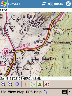
GPSGO displaying a French IGN map scan. |
-
Compatible with most Pocket PC and Windows Mobile based
devices.
-
Works with any NMEA compatible GPS receiver.
-
Use raster map images from any source,
anywhere in the World.
-
Easily zoom and pan around large maps.
-
Simple map calibration within the program
using WGS84 coordinates.
-
No desktop application required.
-
Real-time position and altitude display.
-
Large text GPS info window.
-
Display of historic GPS position trail.
-
Cursor position display.
-
Range/bearing-to-cursor display.
-
Storage and display of custom map position
markers.
-
Enter map point markers in WGS84 lat/long coordinates.
-
Save and load GPS trails.
-
Export trails and points to Google Earth and Google Maps KML files.
-
Ideal for Geocaching, walking etc.
-
Completely FREE.
|
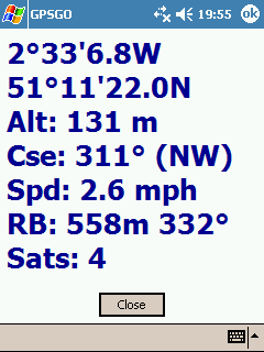
GPSGO function screens
|
Download
The current development version of GPSGO is version 0.94, released 15
Jan 2010, available for download
from the links below:
Version 0.94 for Pocket PC 2003 and Windows
Mobile 5/6 (53KB)
Version 0.94 for Pocket PC 2002 (118KB)
There's no fancy installer - copy the .exe file to a folder on your Pocket PC and run it there.
A good idea might be to copy it to \Windows\Start Menu\Programs for example.
Note that this is still a work in progress version and is not yet as polished as I would
like, but it is functional and has been tested successfully in various locations around the
World.
Source Code
The C++ source code for GPSGO is freely available included with the
GPSMap-OS source code bundle:
Microsoft embedded Visual C++ 4.0
Workspace (280KB)
If you use and like GPSGO please feel free to show your appreciation in
financial form by clicking the button below. All donations, however small, are
greatly appreciated.
Usage Instructions (basic)
To calibrate a map image you need to enter the WGS84 latitudes and longitudes of
three (3) different points on the map. Click the map image at a known position
to place the cursor on it, then select 'Map->Enter Calibration Point...' from
the menu and enter the latitude/longitude of the selected point (which you could
read from Google Earth for example). Repeat for the next two points anywhere on
the map. There's a useful "Use GPS Position" button on the coordinate entry
dialog to allow calibration by actually visiting a point on the map yourself and
using your GPS to provide the coordinate fix.
For details of the other functions of the program please refer to the
GPSMap-OS page.
Feedback
If you try and like this program (or not) please let me know and encourage
continued development and improvement. Feature requests and bug reports are
always welcome.
Web Forum:
http://craporola.freeforums.org

email:
shanks-noospaam@callnetuk.com [Spam prevents me publishing a direct email link - remove the "-noospaam"
bit.]
License
GPSGO is released under the terms of the GNU General
Public License, version 3.
This program is free software: you can redistribute it and/or modify
it under the terms of the GNU General Public License as published by
the Free Software Foundation, either version 3 of the License, or
(at your option) any later version.
This program is distributed in the hope that it will be useful,
but WITHOUT ANY WARRANTY; without even the implied warranty of
MERCHANTABILITY or FITNESS FOR A PARTICULAR PURPOSE. See the
GNU General Public License for more details.
Copyright
This site and its content is copyright (c) 2005-2010 Dr. Matt Voysey, Craporola
Software Inc.
Site last updated:
21-Apr-2010.
| Site Visits: |
 |
Free Counter courtesy of: |
 |
Craporola Software Homepage